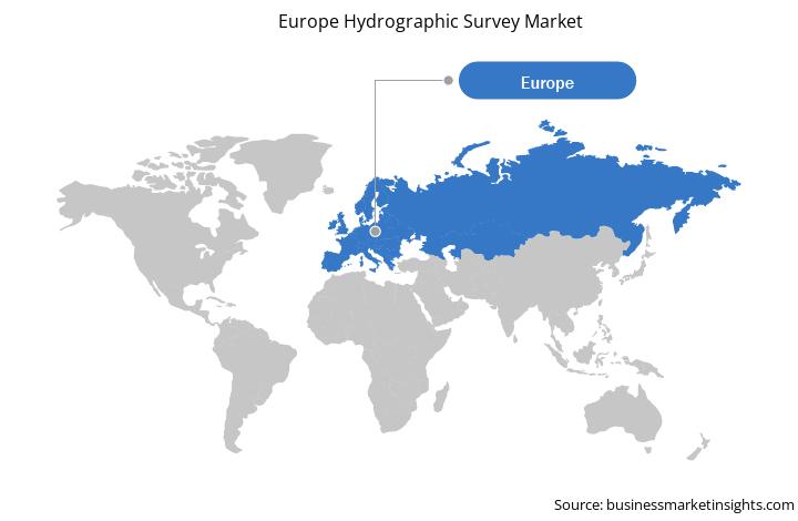
Europe Hydrographic Survey Market
Germany, France, the UK, and Italy are among the prime contributors to the European hydrographic survey market. The market in the region is propelled by rising marine projects, which demand hydrographic surveys for the safety of the ecosystem and boaters. For instance, the Ireland, Northern Ireland, and Scotland hydrographic survey project was designed after the Maritime and Coastguard Agency (MCA) identified the priority areas drawn from the increased shipping, marine conservation zones, and marine renewables. The MCA led the project—along with the partners in the Marine Institute Galway, Northern Lighthouse Board, the Geological Survey of Ireland, and Agri-Food and Biosciences Institute—and the information was provided to the UK Hydrographic Office. Several government agencies in the region carried out hydrographic surveys for ports and harbors, exploration, and other activities. For instance, the Danish Geodata Agency—a Danish state-owned central agency responsible for surveying—conducts hydrographic surveys and charting in Denmark. It creates nautical charts of the waters nearby Denmark, the Faroe Islands, and Greenland. The survey is carried out with personnel and ships from the Royal Danish Navy. Growing maritime commerce and transport and increase in the number of offshore oil & gas projects are the major factor driving the growth of the Europe hydrographic survey market.
Furthermore, due to the COVID-19 outbreak, Russia, UK, France, Spain, Italy, and Germany are some of the worst affected member states in the European region. Businesses in the region face severe economic difficulties as they had either to suspend their operations or substantially reduce their activities. Due to business lockdowns, travel bans, and supply chain disruptions, the region witnessed an economic slowdown in 2020 and most likely to witness till Mid-2021. The member states of Europe, such as Italy, Spain, and Germany, have implemented drastic measures and travel restrictions to limit coronavirus spread among its citizens. European countries represent a major market for hydrographic survey due to increasing adoption and growth in marine safety and flourishing oil & gas industry. However, due to COVID-19, the major offshore projects that demand hydrographic surveys to perform analysis on water depth and other activities have seen a sharp decline in European countries due to halt in projects. These factors are expected to have a direct impact on hydrographic survey market growth in European countries. Russia, Italy, Germany, UK, and France hydrographic survey markets are anticipated to see the worst impact till Mid-2021.
Strategic insights for the Europe Hydrographic Survey provides data-driven analysis of the industry landscape, including current trends, key players, and regional nuances. These insights offer actionable recommendations, enabling readers to differentiate themselves from competitors by identifying untapped segments or developing unique value propositions. Leveraging data analytics, these insights help industry players anticipate the market shifts, whether investors, manufacturers, or other stakeholders. A future-oriented perspective is essential, helping stakeholders anticipate market shifts and position themselves for long-term success in this dynamic region. Ultimately, effective strategic insights empower readers to make informed decisions that drive profitability and achieve their business objectives within the market.
| Report Attribute | Details |
|---|---|
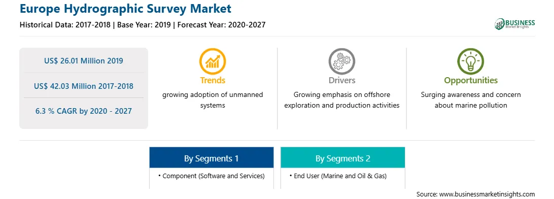
| Market size in 2019 | US$ 26.01 Million |
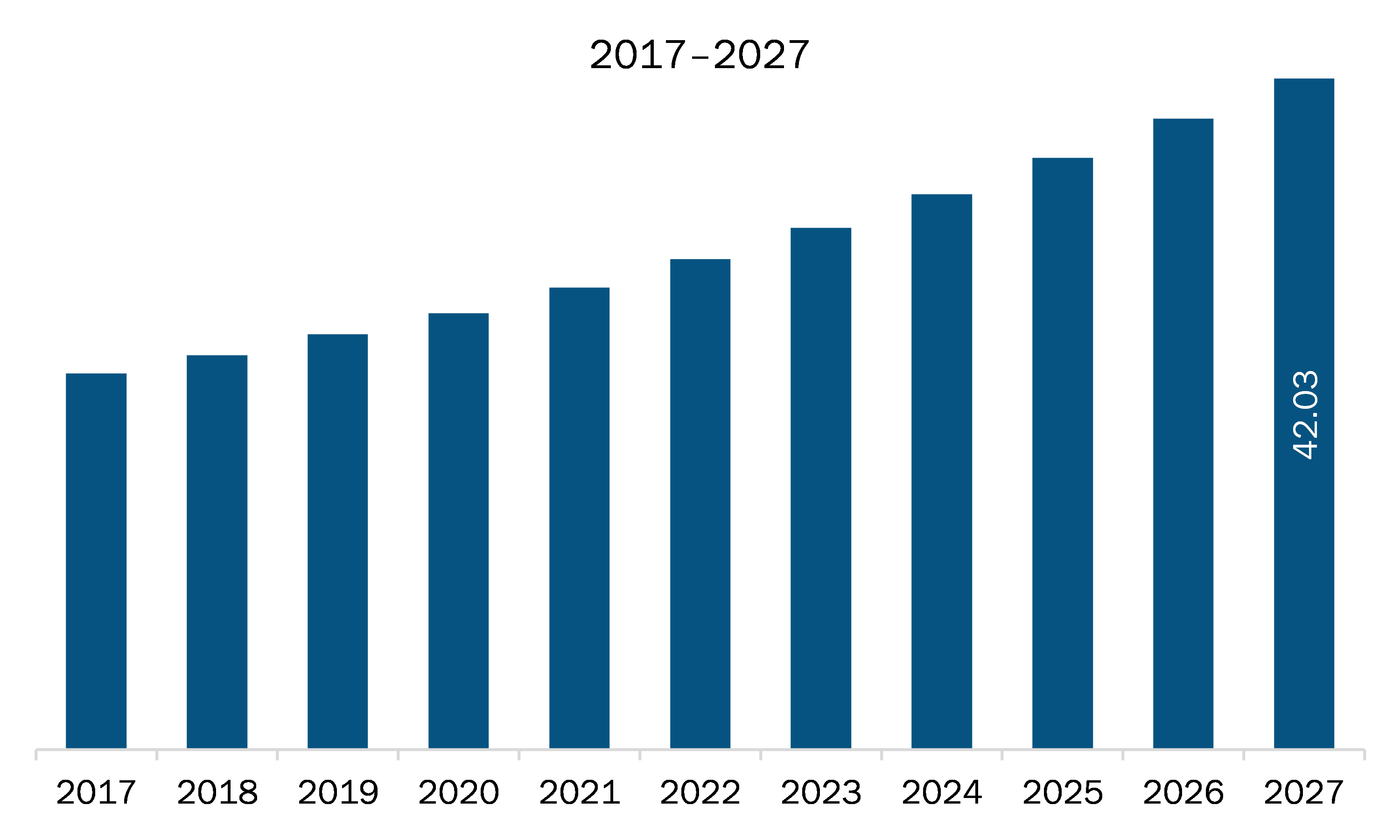
| Market Size by 2027 | US$ 42.03 Million |
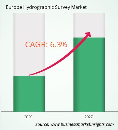
| Global CAGR (2020 - 2027) | 6.3 % |
| Historical Data | 2017-2018 |
| Forecast period | 2020-2027 |
| Segments Covered |
By Component
|
| Regions and Countries Covered | Europe
|
| Market leaders and key company profiles |
The geographic scope of the Europe Hydrographic Survey refers to the specific areas in which a business operates and competes. Understanding local distinctions, such as diverse consumer preferences (e.g., demand for specific plug types or battery backup durations), varying economic conditions, and regulatory environments, is crucial for tailoring strategies to specific markets. Businesses can expand their reach by identifying underserved areas or adapting their offerings to meet local demands. A clear market focus allows for more effective resource allocation, targeted marketing campaigns, and better positioning against local competitors, ultimately driving growth in those targeted areas.
The Europe hydrographic survey market is expected to grow from US$ 26.01 million in 2019 to US$ 42.03 million by 2027; it is estimated to grow at a CAGR of 6.3 % from 2020 to 2027. Technical developments in hydrographic survey software and services is expected to accelerate the Europe hydrographic survey market. Hydrographers play a key role in identifying the ocean environment and the production of nautical charts for navigation safety. In addition to the primary role of hydrography, the end users are increasingly seeking real-time data for the sustainable management of marine resources and protection of coastal infrastructure. They need hydrographic data to manage the challenges related to climate change and urbanization in coastal communities. Thus, hydrographic surveying and the roles of experts in this field are in experiencing a paradigm shift, and rise in the adoption of disruptive technologies, solutions, and techniques is likely to boost survey capacity and productivity, simultaneously mitigating the risks and costs involved. The integration of advanced technologies such as artificial intelligence (AI), virtual reality (VR), and automated data collection is emerging as the next step in the further development of the hydrographic survey industry. AI, machine learning (ML), and forward-looking sonar (FLS) transform hydrographic data collection, processing, analysis, and presentation. The technology integration would enable the close-to-real-time transmission of hydrographic data to cloud in the coming years. Moreover, several methods of processing data using complex algorithms and AI are in the developing phase. The introduction of AI and ML capabilities would allow enterprises to shift from being product-centric to data-centric, which would enable enterprises to expand their product and service portfolios, thereby allowing them to ensure greater client satisfaction. Advanced technologies are swiftly gaining prominence in the marine, and oil & gas sectors, and the rising use of hydrographic survey software integrated with advanced technologies is emerging as a prominent trend in the Europe market.
In terms of component, the software segment accounted for the largest share of the Europe hydrographic survey market in 2019. In terms of end user, the oil & gas segment held a larger market share of the Europe hydrographic survey market in 2019.
A few major primary and secondary sources referred to for preparing this report on the Europe hydrographic survey market are company websites, annual reports, financial reports, national government documents, and statistical database, among others. Major companies listed in the report are BeamworX BV, Esri, Eye4Software B.V., HYPACK / Xylem Inc., IIC Technologies, Moga Software s.r.l., Norcom Technology Limited, OceanWise Limited, Quality Positioning Services B.V. (QPS), Teledyne Marine (Teledyne Technologies Incorporated).
The Europe Hydrographic Survey Market is valued at US$ 26.01 Million in 2019, it is projected to reach US$ 42.03 Million by 2027.
As per our report Europe Hydrographic Survey Market, the market size is valued at US$ 26.01 Million in 2019, projecting it to reach US$ 42.03 Million by 2027. This translates to a CAGR of approximately 6.3 % during the forecast period.
The Europe Hydrographic Survey Market report typically cover these key segments-
The historic period, base year, and forecast period can vary slightly depending on the specific market research report. However, for the Europe Hydrographic Survey Market report:
The Europe Hydrographic Survey Market is populated by several key players, each contributing to its growth and innovation. Some of the major players include:
The Europe Hydrographic Survey Market report is valuable for diverse stakeholders, including:
Essentially, anyone involved in or considering involvement in the Europe Hydrographic Survey Market value chain can benefit from the information contained in a comprehensive market report.
Office No. 1011, First floor, Farena Corporate Park, Magarpatta-Mundhwa road, Pune - 411028, Maharashtra, India
US:+16467917070
sales@businessmarketinsights.com


 Get Free Sample For Europe Hydrographic Survey Market