2027 年までの北米水路測量市場予測 - 新型コロナウイルス感染症の影響とコンポーネント (ソフトウェアおよびサービス) およびエンドユーザー (海洋、石油およびガス) 別の地域分析
No. of Pages: 90 | Report Code: TIPRE00021045 | Category: Technology, Media and Telecommunications
No. of Pages: 90 | Report Code: TIPRE00021045 | Category: Technology, Media and Telecommunications
北米には、米国やカナダなどの先進国とメキシコなどの新興国が含まれます。技術の発展により、北米はさまざまな企業にとって競争の激しい市場となっています。この地域の企業は、エンドユーザーを満たすために全体的なビジネスプロセスを継続的に開発しています。高品質な製品への要求。現在、米国は、輸入品への依存度が高く、製造および生産施設のアジア経済に対する顕著なアウトソーシングにより、堅牢な港湾インフラと海事部門を誇っています。米国海洋局によると、米国の海上輸送システムは、重量ベースで米国の海外貿易の約 80% を移動させています。この地域は、海上輸送システムを安全かつ効率的に機能させたいという傾向が非常に強いです。北米は、水深、海底と海岸線の形状、水域のその他の物理的特徴に関するデータの取得に重点を置いています。そのため、水域を改善するための効率的なデータを提供する水路測量ソフトウェアとサービスを高度に導入しています。米国海洋大気庁 (NOAA) の測量船は、マルチビーム音響測深機 (音響送受信システム) を使用して水路調査を行っています。このため、海や川のさまざまな活動を測定するための調査を行うために、この地域では水路調査の需要が急増しています。これにより、市場の成長が加速しています。
さらに、新型コロナウイルス感染症の場合、北米、特に米国が大きな影響を受けます。北米は、特に米国やカナダなどの先進国において、イノベーションを促進する政府の有利な政策、巨大な産業基盤、高い購買力により、新しいデジタル技術の導入と開発にとって最も重要な地域の1つです。したがって、産業の成長に対するマイナスの影響は、地域の経済成長に影響を与えると予想されます。現在、米国は新型コロナウイルス感染症の発生により世界で最も深刻な影響を受けている国であり、世界保健機関(WHO)によると、2021年2月8日の時点で感染者数は26,654,965人、死者数は458,544人となっている。米国は、石油と石油の水路調査の著名な市場です。ガスおよび海洋部門。米国、カナダ、メキシコ全土での工場と事業の閉鎖は、水路測量市場の採用に影響を与えています。労働力不足と社会的距離を保つための多くのケースにおける現実的な困難により、石油と石油の供給が妨げられました。米国でのガス活動が停止し、進行中のさまざまなプロジェクトの停止につながる。したがって、水路測量ソフトウェアの統合にも影響を与えました。米国で進行中の新型コロナウイルス感染症危機と危機的状況は、今後数か月間、北米の水路測量市場の成長にマイナスの影響を与えるでしょう。
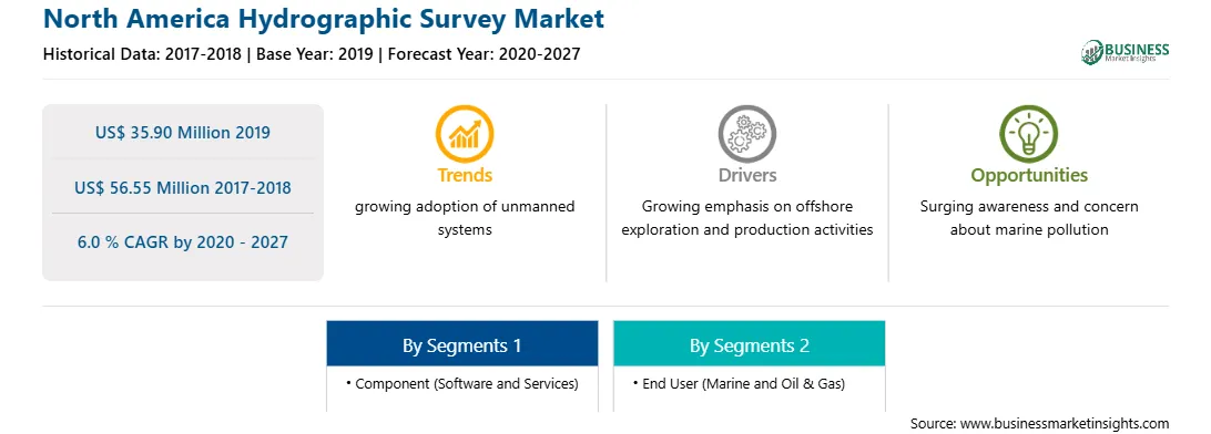
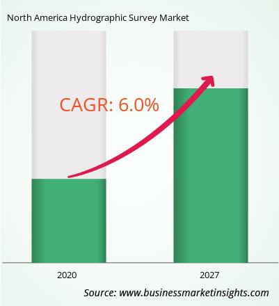
北米の水路測量市場は、2019 年の 3,590 万米ドルから 2027 年までに 5,655 万米ドルに成長すると予想されています。 2020 年から 2027 年までに 6.0 % の CAGR で成長すると推定されています。電力プロジェクトにより、北米の水路測量市場が盛り上がると予想されます。メキシコやカナダなどの北米諸国は、予測期間中に水路調査プロバイダーに多くの成長機会を提供する可能性があります。これらの経済における工業化の成長は都市化をもたらし、その結果、エネルギー消費が急速に増加しました。さらに、家計収入の急増や製造業や重工業の拡大に伴い、エネルギーと電力の需要は増加すると見込まれています。エネルギーとエネルギーの数風力や太陽光発電プロジェクトを含む電力プロジェクトは、北米諸国で急速に増加しています。したがって、特にメキシコのような国では、関連プロジェクトのエスカレーションにつながるエネルギーと電力の需要の増加により、北米地域全体の予測期間中に水路測量市場のプレーヤーに多くの収益性の高いビジネスチャンスが提供されると予想されます。 p>
コンポーネントの観点から見ると、ソフトウェアセグメントは北米の水路測量市場で最大のシェアを占めています。 2019. エンドユーザーの観点から見ると、オイルとオイルは2019 年の北米水路測量市場では、ガス部門がより大きな市場シェアを占めました。
北米の水路測量市場に関するこのレポートを作成するために参照されたいくつかの主要な一次および二次情報源は、企業の Web サイト、年次報告書、財務報告書、政府文書、統計データベースなどです。レポートに記載されている主要企業は、Esri、HYPACK / Xylem Inc.、IIC Technologies、Quality Positioning Services BV (QPS)、Teledyne Marine (Teledyne Technologies Incorporated)、Triton Imaging, Inc.
Strategic insights for North America Hydrographic Survey involve closely monitoring industry trends, consumer behaviours, and competitor actions to identify opportunities for growth. By leveraging data analytics, businesses can anticipate market shifts and make informed decisions that align with evolving customer needs. Understanding these dynamics helps companies adjust their strategies proactively, enhance customer engagement, and strengthen their competitive edge. Building strong relationships with stakeholders and staying agile in response to changes ensures long-term success in any market.
| Report Attribute | Details |
|---|---|
| Market size in 2019 | US$ 35.90 Million |
| Market Size by 2027 | US$ 56.55 Million |
| Global CAGR (2020 - 2027) | 6.0 % |
| Historical Data | 2017-2018 |
| Forecast period | 2020-2027 |
| Segments Covered |
By コンポーネント
|
| Regions and Countries Covered | 北米
|
| Market leaders and key company profiles |
The regional scope of North America Hydrographic Survey refers to the geographical area in which a business operates and competes. Understanding regional nuances, such as local consumer preferences, economic conditions, and regulatory environments, is crucial for tailoring strategies to specific markets. Businesses can expand their reach by identifying underserved regions or adapting their offerings to meet regional demands. A clear regional focus allows for more effective resource allocation, targeted marketing, and better positioning against local competitors, ultimately driving growth in those specific areas.
The North America Hydrographic Survey Market is valued at US$ 35.90 Million in 2019, it is projected to reach US$ 56.55 Million by 2027.
As per our report North America Hydrographic Survey Market, the market size is valued at US$ 35.90 Million in 2019, projecting it to reach US$ 56.55 Million by 2027. This translates to a CAGR of approximately 6.0 % during the forecast period.
The North America Hydrographic Survey Market report typically cover these key segments-
The historic period, base year, and forecast period can vary slightly depending on the specific market research report. However, for the North America Hydrographic Survey Market report:
The North America Hydrographic Survey Market is populated by several key players, each contributing to its growth and innovation. Some of the major players include:
The North America Hydrographic Survey Market report is valuable for diverse stakeholders, including:
Essentially, anyone involved in or considering involvement in the North America Hydrographic Survey Market value chain can benefit from the information contained in a comprehensive market report.
Office No. 1011, First floor, Farena Corporate Park, Magarpatta-Mundhwa road, Pune - 411028, Maharashtra, India
US:+16467917070
sales@businessmarketinsights.com


 Get Free Sample For North America Hydrographic Survey Market